Carding Mill Valley
11th September 2013
The 11th of September 2013 saw 14 members of the Geology group making their way to the Carding Mill Valley in the Long Mynd near Church Stretton in South Shropshire.
The target was the Stretton group which is the eastern limb Longmyndian supergroup syncline of the Precambrian and our guide for the day was Keith Hotchkiss of the Shropshire Geology Society.
Keith started by setting the scene for the deposition of the strata by looking east across the Stretton valley towards the line of volcanic hills which include Caer Caradoc and the Lawleys. These formed as a result of volcanic activity above a subduction zone as Gondwana began to break up 570 MYA. The tectonic activity resulted in a system of faults called the Welsh Borderland faults which run from Cheshire plain to South Wales. The Long Mynd plateau lies between two major components of this fault system, the Church Stretton faults and the Pontesford-Linley fault to the west. Lateral movement along these faults is estimated at 30 to 50km and is still active in modern times. The volcanic hills consist mainly of Rhyolite, Andesites and tuffs and the presence of the more viscous lava Rhyolite suggests the source volcano was close but no site has been identified. Consequent on the volcanic activity a marine basin formed which subsided and into which the erosion products from the volcanoes were deposited which subsequently became the rocks of the Longmyndian supergroup. Later tectonic activity along the South Wales Borderland faults exerted compressive forces to these sediments resulting in the folding of the present day Long Mynd syncline. There is also evidence that the strata suffered a downthrow of approx. 1000m between 30 and 50 MYA as the dip of the Wenlock Edge would indicate that rocks of Silurian age would have been deposited 1000m above Church Stretton but examples of these strata are found in the Church Stretton valley immediately west of the main fault (F1). Incidentally the line of this fault can be seen as a change of slope across the valley and passes under the traffic lights on the A49, so as Keith said if they start to shake, run for it !

The group with Caradoc Hill behind.
The above is a brief description of the area and for a fuller and more accurate history readers should refer to the excellent book by Peter Toghill, “The Geology of Shropshire” (The Crowood press ISBN1861268033)
Our first exposure on the road to the NT car park was of the lowest member of the group, the STRETTON SHALE FORMATION (GR453940). This is a dark coloured mudstone deposited in deep cold water on steep slopes as the shale is a turbidite. The formation contains a layer of Bentonite which has given a date of 567 MYA for the deposition.
Next came a layer of tuff, the BUXTON ROCK (GR450942). This is a hard siliceous grit about 5m thick with quartz veins and is used as a marker horizon for the end of the Strettton shales. It is used locally as a building stone.
Walking up the valley we came next to the BURWAY FORMATION (GR449942). It is called a formation as it consists of a variety of sandstones, siltstones and mudstones. Again turbidic in nature and with no time for sorting of grains this type of rock is referred to as a Greywacke . As with all the Longmyndian strata the dip can be seen as about 70 degrees.
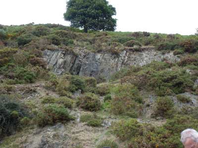
Burway Formation. Note the dip in the rocks.
The next member is again a horizon marker, CARDINGMILL GRIT (GR946443) a coarse sandstone indicating deposit in tidal river bed. The rock also contains mica which comes from the basement rocks. Moving on up the track we passed through another formation of purple rocks consisting of shales, siltstones and sandstones called the SYNALDS FORMATION (GR440948). Lain down in very shallow water with reduced oxygen giving the distinctive colour caused by oxidation of iron. The Synalds Formation contains controversial evidence of Precambrian fossils. Pits in the rock have been identified as fossilised raindrops and/or the trace of soft-bodied creatures. Keith showed examples of fossils from other areas on the Long Mynd which are more certainly Ediacaran fossils. Keith also recounted a tale of Charles Darwin seeking to obtain confirmation of Precambrian fossils in the Long Mynd from Salter and Ramsey in about 1850.
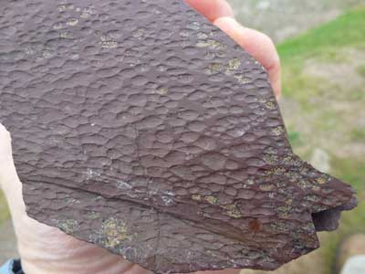
An Ediacaran fossils (probably).
The Synalds formation also includes the BATCH VOLCANICS (GR440948) which are Andesitic ashes that are the last evidence of volcanic eruptions and the horizon marker for the end of the Synalds.
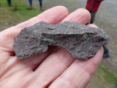
Andesitic tuff.
At this point the two sides of the valley show marked differences caused by insolation and solifluction which caused more erosion on the northern bank as it had more temperature cycles in periglacial conditions. Evidence of erosion of recently placed gabions shows how the relatively small stream is capable of rapid erosion.
Lunch stop.
We had now reached the Lightspout waterfall and consequently the LIGHTSPOUT FORMATION (GR431951). The formation contains bands of resistant sandstones one of which is the cause of the waterfall, it being harder than the rocks up stream or downstream. Just above the waterfall is a good exposure of ripple marks.
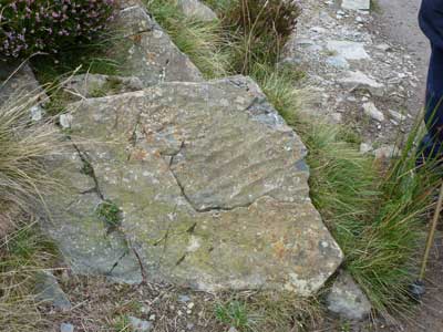
Ripple marks.
The lightspout waterfall is the current ‘nick’ point in the profile of the stream as the stream seeks to regain its original profile prior to the Devensian ice age when an ice sheet filled and gouged out the Stretton valley and left hanging valleys. (The current Stretton valley surface is 30 m above the bedrock and the Strettons sit on ice age deposits and alluvial fans.) How and when the ‘Batch” valleys were cut into the Long Mynd plateau is still debatable but there is significant contrast between the heavily eroded valley below the Lightspout and the flatter plateau immediately above. The marker horizon for the end of the Lightspout formation is the HUCKSTER CONGLOMERATE (GR 429951) but exposures are difficult to find.
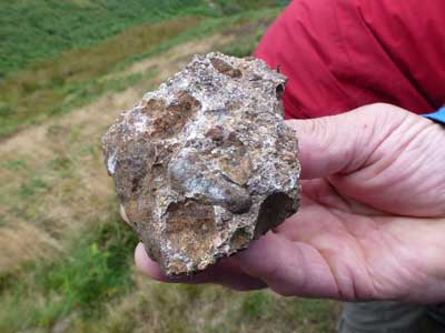
Huckster conglomerate.
As with the ripple marks this is another indication of shallow water deposition. Next exposure was of the PORTWAY FORMATION (GR423954) which is the final member of the Stretton group and consists of bands of sandstone and mudstone. In the exposure a band of mudstone between two bands of sandstone has started to break up as it is weaker than the sandstone but not to the point of becoming a slate as is the case further into Wales but instead is a shale with cleavage.
Finally before descending to the cars we walked across the plateau to a roadside exposure of a large expanse of a river gravel conglomerate with well rounded pebbles including Rhyolites and granite porphyries.
Alan Hughes